The scope of the Map Tool and of geographical zones with or without flight restrictions is limited to the territory of the Federal Republic of Germany and regulated in accordance with the applicable version of the German Rules of the Air Regulations (LuftVO).
The current version of the Map Tool is intended to support pilots of unmanned aerial vehicles (hereinafter: drones) to plan and carry out drone flights. To this end, basic maps of the Federal Republic of Germany and the corresponding geographical zones are provided in the tool. Moreover, pilots can use the Map Tool to check whether their intended flight zone overlaps with any geographical zones.
The map display and the information provided can vary while in use depending on whether you accept cookies and share your location, for example. But don’t worry. You can change your preferences at any time and you can delete the cookies in your browser’s settings.
When you use the tool for the first time, you will be asked by default whether you want to share your location. If you don’t want to share your location or if you have deleted the corresponding cookies, the map focus will automatically be centred on the city of Berlin.
When the map tool is initially loaded or reloaded (Ctrl+R), the geographical areas are switched on and displayed. The "Map layers" menu is expanded on the right-hand side.
In general, the tool is divided into different sections:
The header,
The footer (at the bottom left and right of the map), and
The main section with the actual map and controls.
The header is found in the upper section of the Map Tool and contains the different navigation elements as well as external links. The external links can be used to access the other pages of the Digital Platform for Unmanned Aviation and the website of the Federal Ministry for Digital and Transport.
The following elements are shown in the header:
Element
Description
Opens the homepage of the Digital Platform for Unmanned Aviation (dipul)
Footer (lower left and right corner of the screen)
The footer is divided into two parts and is located at the bottom left and right of the map. It contains navigation elements / links to further pages or information of the Digital Platform for Unmanned Aviation.
The left side of the footer contains navigation elements / links that provide information on the licence conditions of the map material used.
The following elements and information can be accessed via the right footer:
Element
Description
Publication data
Opens the publication data page: Information on the responsible persons as required by law.
Privacy
Opens the privacy page: Information on data protection as required by law.
User information
Opens the user information: Legal notes, legal base, disclaimers.
Release Notes
Provides information on the current version of the Map Tool that is currently used.
The main section of the screen displays the map with the various control elements. The following description of the main section and navigation elements displayed assumes that the user is opening the map tool for the first time.
The following elements are shown in the main section:
Element
Description
Notification field
If you have denied access to the localisation function of the browser, this information field is displayed for several seconds. This field is also displayed if you press the button 'Find my location' when the localisation is switched off.
Find address or place
Find place/address function with suggestions. Valid parameters: Town/city, postal code, street (also with house number) or coordinates (WGS84) in degrees (e.g. 52° 30' 52.218" N 13° 21' 0.3888" E) or decimal degrees (e.g. N 52.512578 E 13.321891).
Position of placemark
Provides the exact position of the placemark when it is placed on the map.
Notification field
The display of the geographical areas depends on the zoom level used (height from which the map is viewed). If the zoom out level for displaying the geographical zones is too large, the notification is displayed for several seconds.
‘Show map layers’ tab
Use this tab to open the ‘Map layers’ menu and display a list of all geographical zones where flight restrictions currently apply. Activate/Deactivate the checkbox next to a layer to display/hide the zone or activate the ‘All map layers’ checkbox to display/hide all zones.
'Map layers' menu, show / hide the geographical zones
For the sake of clarity, the individual geographical zones are grouped thematically over two levels (superordinate and subordinate group) and can be shown or hidden in a wide variety of constellations. There are no limits to the possibilities (show/hide all map layers, show/hide on different group levels, etc.). To show or hide geographical zones, select the check box or the name of the corresponding group. By selecting the triangle in front of the corresponding superordinate group, you can expand or collapse the group, e.g. to select subordinate groups.
Geographical zones are only displayed from a scale of less than or equal to (<=) 10 km. If the names of the geographical zones are greyed out, use the zoom function ("Zoom in") to adjust the scale in order to see the geographical zones.
'Show geographical zones' tab
This tab is located below the map layer tab. It opens and closes the menu 'Overlapping geographic zones'. The menu provides validation options to check for overlap between planned flight area and geographical zones. The menu offers two options: 'Set Point' and 'Draw Circle', which are described below.
Option 'Set point':
Result View:
Result Details View:
Menu 'Overlapping geographical zone', option 'Set point'
with the views: Results View and Results Details View.
"Set point" option
This option is the default setting (button 'Set point' is blue) after calling up the Map Tool or after a refresh (Ctrl+R) of the browser. It allows you to set a point on the map and checks for the presence of geographical zones at its position. To do this, move the cursor over the map and confirm at the desired point by selecting (e.g. clicking the left mouse button). The point is indicated by the placemark and the validation is carried out at this location.
The overlap check also works when geographical zones are hidden.
Result View After a check has been carried out (e.g. setting the cursor on the map), the results of the check are displayed in the menu 'Overlapping geographical zones' below the buttons 'Set point' and 'Draw circle' (see picture 'Result View').
Possible results:
No restrictions due to geographical zones. or
A drone operation is legally restricted by at least one geographical zone:
Main group name of the geographical zones
Name of the geographical zone
...
...
Result Details View By selecting the affected geographical zone in the result list (clicking the name), further details about the affected geographical zone, such as lower and upper boundary and the legal notice, are displayed.
With the bin icon you can delete old results to start a new validation.
Even if the Map Tool does not show any restrictions due to geographical zones, this does not necessarily mean that you are allowed to fly your drone in this area. There may be other limiting factors that are not currently listed by dipul.
Option 'Draw circle': Result View: Result Details View:
Menu 'Overlapping geographical zone', option 'Draw circle',
with the views: Results view and Results details view.
'Draw circle' option
You select this option by selecting the 'Draw circle' button. When this option is active, the button should be blue, as shown in the picture. With this option, a circular flight area can be drawn on the map or entered into the form using the corresponding parameters.
The check for overlap between the planned flight area and any existing geographical zones is carried out via the button 'List geographical zones in circle'.
The overlap check also works with hidden geographical zones.
The presentation of the results is similar to the presentation of the results as under the option 'Set point', but is listed here again for the sake of completeness.
Result View
After a check has been carried out (e.g. setting the cursor on the map), the results of the check are displayed in the menu 'Overlapping geographical zones' below the buttons 'Set point' and 'Draw circle' (see picture 'Result View').
Possible results:
No restrictions due to geographical zones. or
A drone operation is legally restricted by at least one geographical zone:
Main group name of the geographical zone
Name of the geographical zone
...
...
Result Details View
By selecting the affected geographical zone in the result list (clicking the name), further details about the affected geographical zone, such as lower and upper boundary and the legal notice, are displayed.
With the bin icon you can delete old results to start a new validation.
Even if the Map Tool does not show any restrictions due to geographical zones, this does not necessarily mean that you are allowed to fly your drone in this area. There may be other limiting factors that are not currently listed by dipul.
Show/hide 'Weather at selected location' tab
This tab is located under the Overlapping Geographical Areas tab, which can be used to show or hide the "Weather at selected location" menu.
'Weather at selected location' area
The 'Weather at selected location' area opens after the 'Weather at selected location' tab has been selected. The picture shows the area after the initial start of the Map Tool or after a refresh (Ctrl+R) of the browser. To obtain the weather data for a planned flight location, you must enter the location, e.g. via 'Find address or place'. For more information on the "Weather at selected location" section, click here.
By default, the map is oriented with the north up. If you want to change the orientation of the map or if you have changed the orientation, you can click on this button to align the map with north up again. You can find out how to change the orientation of the map here.
Location mark
Click on the map to place the location mark. The exact position of the mark will be shown in the 'Placemark position' field. In addition, the system tests whether geographical zones exist at this position. The result will be displayed in the menu 'Overlapping geographical zone - Result view'.
Scale with length data and unit. If the scale is shown in red, no geographical zones can be displayed. Zoom in to display geographical areas.
'Show background map' button
Changes the map background for choosing between grayscale, night vision or satellite view, for example.
'Find my location' button
This button works in conjunction with the localization if permitted. In this case, the map is centred on the currently located location. If the use of the localization function has been denied, the message box 'Location sharing deactivated' appears when by selecting this button.
'Zoom' buttons
Zoom in/out of the map to display fewer/more details.
The display of the geographical zones depends on the selected zoom level. Geographical zones are only displayed from a scale of less than or equal to (<=) 10 km, and only if previously they have been activated in the Map Layers menu.
Many of the navigation elements in the header and footer of the Map Tool are just external links to other pages or provide access to knowledge/information that does not require further description. Therefore, only the functionality of the map is described below.
Just like many other map navigation applications, the Map Tool can also be used intuitively via keys, the mouse or touch screen (depending on the device).
Move the cursor (e.g. crosshair) to a position on the map. Left-click and hold while you drag the map. Now you can move the map to the required location. Repeat this procedure, if necessary, until you have reached/found the required location. For large distances, adjust the scale of the map (zoom in / out of the map) to move a larger section. When you have found the location, you can mark it (by left-clicking). A blue location marker will appear and the system will test to see if there are any geographic areas at that point.
Move the cursor to a position on the map with a mouse click or by repeatedly pressing the Tab key. Ideally, you first center the place you want to focus on in the middle of the visible browser area and position the cursor directly over it. Now roll the mouse wheel forwards or backwards or press the plus (+) respectively minus (-) button. The map enlarges or shrinks according to the chosen direction.
Instead of using the mouse wheel, you can also use the zoom buttons on the map (see figure). You can also access this via the keyboard by repeatedly pressing the [Tab] key. Use [Enter] or a mouse click to trigger the desired function.
The map can also be enlarged by double-clicking with the left mouse button.
On a device with a touchscreen (e.g. smartphone) you can enlarge the map by placing two fingers (e.g. thumb and forefingerr) on the map and pulling them apart. You zoom out with the reverse gesture by pinching the two fingers together
The level of detail of the map and the size of the zone shown depend on the zoom level used (i.e. the height from which the map is viewed). When the zoom element on the screen is active, click on (+) to zoom in and on (-) to zoom out. Also showing geographical zones in the map depends on the selected zoom level. Geographical zones are only displayed from a scale of less than or equal to (<=) 10 km. A prerequisite for displaying geographical areas is that they have previously been activated in the 'Map layers' menu.
The following applies: Low magnification: little detail, large zone displayed High magnification: a lot of detail, small zone displayed
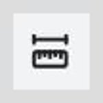
With a click on this button you activate the distance measurement. After activating the button, place the mouse cursor on the map to the starting point of your measurement. Confirm this point by clicking the left mouse button. Release the left mouse button and move the mouse to the end measurement point, which you confirm again with a click. The measurement section is shown by a red line on the map. The distance value is displayed at the end of the measurement path. Click the button again to deactivate the distance measurement.
The orientation of the map on the screen is indicated by the compass needle (see picture). The (black) tip of the compass needle points north on the map. By default, north is up with the tip of the compass needle pointing to the top of the screen. There are several ways to change the orientation of the map, rotating the map around the center of the screen:
Move the cursor to the map. Pressed [Alt] + [Shift] and held down the left mouse button and mouse moved up or down or sideways to the left or right or in circles.
Alternatively, you can also rotate the map with keys. To do this, you have to choose option 'Set point' in menu 'Overlapping geographical zones'. After setting the placemark on the map, you can rotate the map by using [a] or [d] key.
To align the map with north up again, press the button 'Reset map orientation' (compass needle).
You can change the background map depending on your preferences and needs. To do so, left-click on the ‘Show background map’ navigation element or use the Tab button to navigate to the element and press Enter to activate it. Now, the element is expanded and a choice of layouts displayed. Click left on the required layout or use the Enter button to activate it.
The map is now displayed with your chosen layout. A click on the button "Show background map" closes the menu.
You can also input the required target zone or location directly via the search field in the upper left section of the Map Tool. Place the cursor in the search field, and enter the location via the keyboard. The system searches for locations of this name and displays them below the search field. If no locations are shown, additional letters need to be added until the location is found and displayed. It might also be necessary to correct the spelling. Now you can choose a location from the displayed list. If more than one location is shown for a name you have entered and you did choice nothing, the first list entry is chosen automatically when the Enter key is pressed. The focus of the map will then be moved to the chosen location and a new blue (location) marker is displayed and the tool checks if there are any geographical zones at that location and displays the results.
In addition to place name, street, postal code, the location search also accepts coordinate information for degrees (e.g. 52° 30' 52.218" N 13° 21' 0.3888" E) or decimal degrees (e.g. N 52.512578 E 13.321891) in the WGS84 reference system.
The location search has influence on the function 'Draw circle'. By executing the location search, the function 'Set point' is selected. A drawn flight area (circle) or previous validation results will be overwritten.
The placemark is linked to the 'Set point' function, which is enabled by default after loading the Map Tool. The 'Set point' functionality can also be selected from the 'Overlapping geographical zones' menu.
If the placemark is set on the map (cursor over the map and click on the left mouse button),
the exact coordinates of the position are given in the "Placemark position" field,
it will be checked if there are any geographical zones at the placemark position and listed accordingly in the menu 'Overlapping geographical zones' menu,
the map can be rotated using the keyboard (see here).
Menu to show / hide the geographical zones where flight operations are restricted. Click on this control element to show / hide the geographical zones defined based on the current German Rules of the Air Regulations (LuftVO). You can select individual elements or a combination of elements. To do so, left-click on the ‘Show map layers’ button or use the Tab and Enter keys to navigate to the element and open it. Now, the menu 'Map layers' opens and several geographical zones are displayed. You can show/hide the individual zones by activating/deactivating the corresponding checkbox(es). This shows (Show zone) or hides (Hide zone) the checkmark in the checkbox. Your changes are immediately reflected in the map. The geographical zones are grouped thematically across two levels. For example, the superordinate group Air Traffic consists of the subordinate groups Aerodromes, Airports, Control Zones and Restricted Areas. By clicking on the triangle in front of the corresponding superordinate group, you can show or hide the superordinate group to access the associated subgroups. Showing and hiding corresponding geographical zones can also be carried out individually at subgroup level.
The display of the geographical areas depends on the zoom level. If the zoom level is low, no geographical areas are displayed. You can adjust the scale appropriately by using the zoom in button.
The following is a description of how to plan a flight route (in the current version, only circles are available as flight zones) and how to check for overlaps with existing geographical zones based on the German Rules of the Air Regulations (LuftVO). This check can also be carried out without activating the geographical zones. The planned flight zone can either be defined by entering the flight parameters in the corresponding input fields in menu 'Overlapping geographical zones - Option Draw circle', or by drawing a circle (the flight zone) directly into the map.
Draw circle
For checking a flight area (currently only circles), go to the menu 'Overlapping geographical zones - Option Draw circle'. Select 'Draw circle' if not already activated (cf figures). Now move the cursor (the look of the cursor changes to a crosshair) on the map to the centre of your planned flight area and confirm the position by clicking the left mouse button or pressing [Enter]. Release the left mouse button. The radius of the circle (0m) appears at the position of the cursor (centre of the circle).
When the centre point has been defined, you first must release the mouse button to draw the radius. If you keep pressing the mouse button, the map moves and no radius can be drawn.
Now move the cursor to the outer edge of the planned flight area. A blue circle is displayed around the defined centre point. The radius of the circle is adjusted during the drawing process. To define the edge or end of the circle of your planned flight zone, mark it by left-clicking or pressing [Enter}. The flight area is now displayed as a blue circle without a radius and with a cross in the centre. In addition, the button 'List geographical zones in circle' is shown active (blue). Manual corrections to the radius of your flight zone can be do in the ‘Radius (max. 3 000m)’ field in the ‘Overlapping geographical zone’ menu. The height of your planned flight can be determined in the ‘Altitude above ground level (m)’ field (default is 0m).
After the flight area has been defined, the ‘List geographical zones in circle’ button is activated. Select the button to start the check. The system now checks the flight zone you have defined for overlaps with any geographical zones and lists them under the ‘Overlapping geographical zones’ menu item. The menu item "Overlapping geographical zones" opens automatically regardless of the result of the check if it was closed.
Note: By searching for a new location in the field 'Find address or Place' the Map Tool changes to the option 'Set point'. The results of the check from "Draw circle" and the marked circle will be overwritten in this case.
Useful information on the check To check for overlaps between the planned flight zone and geographical zones, the tool uses a cylinder formed by the parameters height and radius. The parameters must be expressed in metres. If the cylinder touches, crosses or is located within one or more geographical zones, they are displayed in a list. The check can also be performed when no geographical zones are displayed. Permissible values: - Height >= 0 m - Radius: 0 to 3000 m
The menu item 'Overlapping geographical zones' should be open after the check has been carried out or should be opened and displayed automatically.
If this is not the case, please open the menu manually (focus on the corresponding button and confirm with the left mouse button or by pressing the [Tab] key and [Enter] several times). If necessary, carry out the check again (cf. 'List geographical areas in the circle').
Regardless of the type of check (set point or draw circle), results should be displayed in this menu below the buttons 'Set point' and 'Draw circle', if a check for the presence of geographical areas has been executed.
Possible results are:
No restrictions due to geographical zones. or
A drone operation is legally restricted by at least one geographical zone:
Superordinate group name of the geographical zones
Name of the geographical zone
...
...
In this view, the affected geographical areas are displayed with regard to their thematic group membership in the corresponding superordinate group.
Even if no restrictions were found by the map tool, this does not necessarily mean that you are allowed to fly your drone in this area. There may be other limiting factors that are not currently listed in dipul. If geographical zones are listed under this menu item, a flight is only possible under certain conditions. Therefore, check all the zones listed under this item. Make yourself knowledgeable, obtain necessary permits from official or private bodies and take the necessary and required measures. You can find details on the specified zones by selecting the corresponding list entry (place the mouse pointer on the list entry and confirm with the left mouse button).
The detailed view of a geographical zone opens when you selectthe name of the geographical zone displayed in the results view after checking for the presence of geographical areas. To do this, place the cursor on the corresponding name and confirm by clicking on the left mouse button. The details of the corresponding geographical area are displayed.
In the detailed view, you will find further information, such as the lower and upper altitude limits of the geographical zone and a reference to the paragraph/section of the German Rules of the Air Regulations (LuftVO) based on which the geographical zone was defined.
If you want to fly in a zone with several affected geographical zones, you have to obtain permission from all relevant parties.
Under the "Weather at selected location" tab, you can view the current weather forecast for your planned flying area. The weather forecast is provided by a service of the German Weather Service (DWD). The weather forecast is based on the ICON-D2 model, which is obtained at 07:00 and updated every 3 hours.
Note that weather data is only displayed if a potential flight area has been actively determined by you beforehand. Locating your position via the browser is not sufficient, as your current flight planning location will not necessarily be the later flight location.
The determination and availability of the weather forecast at the selected location is triggered by:
Via the 'Find address or place' field at the top left edge of the map (currently not available due to an error),
After a potential flight area has been selected, the weather data can be viewed via the 'Weather at selected location' menu by left-clicking on the weather tab. After the menu opens, the weather data for the next 24 hours is displayed by default at the surface. The relative humidity and temperature are indicated on the surface at a height of 2 metres above the ground, the wind at a height of 10 metres above the ground.
The currently set altitude is displayed in the selection menu 'Select altitude'. In order to get a comprehensive picture of the prevailing weather conditions in the selected flight area, the altitude can be varied in 50 m steps via this menu.
Select weather according to flight altitude
To do this, click in the blue-edged input field with the height currently indicated (surface) or press the space bar to select. The selection menu with the possible values opens. After selecting a value, the selected value is displayed in the field and the weather data below the corresponding weather symbols is updated accordingly.
Legend
An explanation of the weather symbols shown can be called up via the button (triangle) in front of the legend.
To do this, place the cursor over the triangle, activate the triangle switch. The list with symbols and explanations opens. The time according to the Central European Time Zone (CET), the temperature in degrees Celsius, the wind in m per second, the precipitation in % or snowfall in cm per hour, the total coverage in % and the relative humidity in % are displayed.
In addition, weather-dependent values may be highlighted in colour and in bold type. These values indicate critical weather conditions. Please note that the critical values given can only be a guideline.
It is quite possible that your drone may have problems flying even outside critical weather data and you should refrain from flying. Check the data sheet of your drone in this regard.
Use the ‘Find my location’ button to centre the map on your current position (if you have chosen to share your location). You can centre the map over your own position at any time using the "Find own location" button (if localisation is enabled). If localisation is not activated, a message will appear stating that location sharing has been deactivated. In this case, there is also no focus on your location.
During the development of dipul, value was placed on a web interface that can be operated with the keyboard to optimally support people with motor disabilities and screen reader users. At this point, the keyboard operation of the map tool is explained.
The following commands are always available:
Keystroke
Function
[Tab]
When pressing the tabulation key, the next available interaction element will be selected.
[Shift]+[Tab]
This keystroke combination allows you to go back to the previous element.
Operate special functions of the map tool using the keyboard
Most map tool functions can also be controlled by keyboard. In this section we will detail it more.
Function
How to use
Find address or place
Tab to the 'Find address or place' field. There you can input an address. With arrow keys you can choose the right address.
Information about geographical zones for a selected area
Tab to the 'Overlapping geographical zone' menu. Open it. Inside is a toggle button. Use the arrow keys to select either 'Set point' or 'Draw circle'. When using 'Draw circle', several form fields are available (longitude, latitude, radius, height above ground), which you can fill with values. With [Tab] you get to the next field, with [Shift]+[Tab] you go back one field. Pay attention to a maximum value of 3000 m for the radius. When all fields are filled in, press the button 'List geographic zones in the circle'. You will then receive a list of geographical zones found in this area. Each zone can be selected with [Tab].
Zoom in
For zoom in of the map you have got several options:
Tab to the „Zoom in” button. With [Enter] key you enlarge the map section.
Tab to the map activation (this is then framed). Press [+] to enlarge the map section.
Zoom out
For zoom out the map you have got several options:
Tab to the „Zoom out” button. With [Enter] key you reduce the map section.
Tab to the map activation (this is then framed). Use the [-] key to reduce the map section.
Find my location
To centre the map over your location tab to the 'Find my location' button and execute the function by [Enter] key.
Move map
You can move the map when you tab to the map activation (it is then framed). From there you can move the map in the desired direction using the arrow keys.
Rotate map
To rotate the map, tab to the map activation (it is then framed).
Press the [a] key to rotate the map counterclockwise.
Press the [d] key to rotate the map clockwise.
When you are on the compass needle and press [Enter], reset the rotation to 0°.
"Click on Map" (Set point)
This function indicates the current coordinates and the clicked address when the mouse is clicked on the map. You can activate this via the keyboard using the "Set point" function available in menu 'Overlapping geographical zones'.
To do this, tab into the menu "Overlapping geographical areas".
If old values are still entered, tab to the bin symbol and press [Enter] to delete them.
Tab to the toggle switch and set it to 'Set Point' with the arrow keys.
Then press [Shift]+[Tab] several times until the map frame is focused.
Use the arrow keys to move the map to the desired point. The point is highlighted in blue.
Press [Enter] to fix the point and get the address.

")


 German